

Research highlights geothermal prospectivity mapping of Brazil using open-access data
Energy Disrupter
 Jalapão State Park, Tocantins, Brazil (source: Bart van Dorp / flickr, Creative Commons)
 The research of Lacasse et al (2022) highlights the potential of using open access data to identify high-potential geothermal areas in Brazil.
Christian Lacasse from the Geological Survey of Brazil has published a research paper on the use of GIS for the compilation and processing of open-source data to ultimately generate a prospect map for geothermal resources in Brazil. With the author’s permission, we are publishing highlights of the research on ThinkGeoEnergy.
The study has been published in Geothermics (https://doi.org/10.1016/j.geothermics.2021.102321). Interested readers may get in touch with the primary author via LinkedIn.
In order for countries to achieve a decarbonisation of their economy and a clean energy transition it becomes crucial to discover new geological areas favorable for:
1) the production of geothermal electricity (e.g. ORC/Kalina binary plants) as part of the renewable matrix, with the smallest land footprint (m2/GWh) and most stable baseload (i.e. regardless of weather conditions) compared to wind and solar photovoltaic plants;
2) the safest underground storage of CO2 (e.g. involving mineral carbonation) guaranteeing the highest petrophysical stability with zero risk of seepage to the atmosphere; and
3) the exploitation of natural hydrogen with the cheapest production cost compared to green hydrogen and blue hydrogen that rely respectively on water electrolysis and carbon capture storage (CCS).
GIS integration of open access georeferenced geological, geophysical and well information, aided by the development of machine learning algorithms such as exemplified in a recent study carried out by the Geological Survey (SGB-CPRM) and National Observatory (ON) in Brazil for Enhanced Geothermal Systems (EGS), should be more widely implemented and validated worldwide as a low cost effective method to produce prospectivity maps on a regional scale for geothermal energy, CO2 storage, and natural hydrogen potentials.
To this aim a prospective model is first built on critical factors of evaluation that are grouped under categories and assessed along separate work streams. Score and weight in intermediate evidence maps are assigned using statistical criteria or estimated based on expert opinion, referred as data-driven or knowledge-driven models respectively – models already adopted for prospectivity mapping of critical raw materials that are also essential for achieving the energy transition.
The convergence of these work streams then leads to the construction of favorability maps that can provide stakeholders with the necessary geoscientific deliverables for decision making on further exploration and development of delimited target areas and blocks to be auctioned.
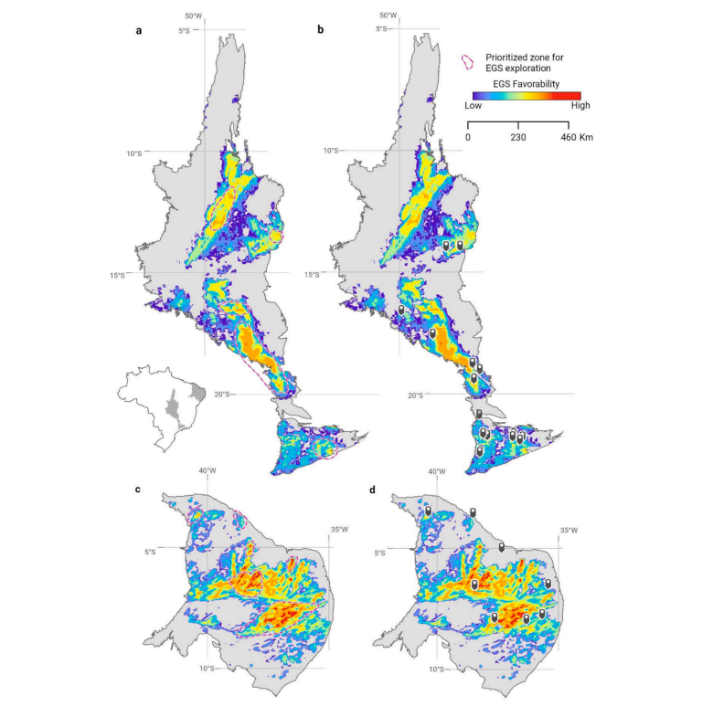
The generated models show the influence of the occurence of thermal springs on the predicted EGS favorability while also supporting the existence of natural fluid flow pathways through deep-seated faults across granites. The authors further note that the integrated model can be improved by integrating other data sets and can be used in complement of the EGS Global Protocol of Beardsmore et al. (2010).
The authors’ work has demonstrated the value of using open-access georeferenced data for a cost-effective method of regionally mapping the favorability of EGS geothermal resources in hot dry rocks of low porosity. The study has benefited from decades of data collection as part of mineral prospectivity mapping.
Source: Christian Lacasse via Linkedin
Related Posts:
 Utah FORGE publishes Wiki dashboard for open-access data
- Video highlights drone use for inspection of EDC’s…
- New study highlights potential of binary geothermal…
- KenGen breaks ground on geothermal-powered data…
- Earths Energy starts scoping study on geothermal for…
- ETIP-Geothermal launches geothermal research product…
- NREL study highlights emissions reduction potential of BECSS
- Registration open for Geothermal AInnovation Competition


